 |
The new reporting, mapping and graphing module allows you to now generate on screen reports, maps and in the future also graphs.
The GIS module provides a spatial view of MIG registered projects, thematic layers for MIG expenditure and service delivery backlogs. At present the capability of the GIS module is confined to the display of thematic layers. In the next phase of development the updating of spatial information at community level will be possible.
Benefits of the GIS Module:
• All the data that resides in the MIG-MIS is spatially enabled.
• The geographic spread of MIG registered projects in relation to other entities can be analysed.
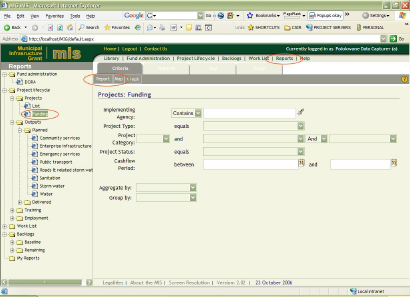
To generate a report:
1. Click Reports on the Application Menu. (Note that the old reports in the Project Lifecycle and Funding Administration applications will still be available for a few weeks, after which they will be removed).
2. Select a report topic of your choice.
3. Optionally specify filter criteria to restrict your report to a specific Agency, Project Type, Project Status, etc.
4. Click Report on the Action Bar.
 Contents
 Index
Index Search
 Previous
 Next
Next